
Big and Small Okrostskali Lake


About Big and Small Okrostskali Lake
Best time to visit:
July, August, September
Okrotskali Lakes (same as Okrostskali Lakes) - Big Okrotskali Lake and Patara Okrotskali Lake, located in Upper Svaneti, Mestia Municipality, on the border of Svaneti and Abkhazia, on the eastern slope of Khojali Range (branch of Kodori Range).
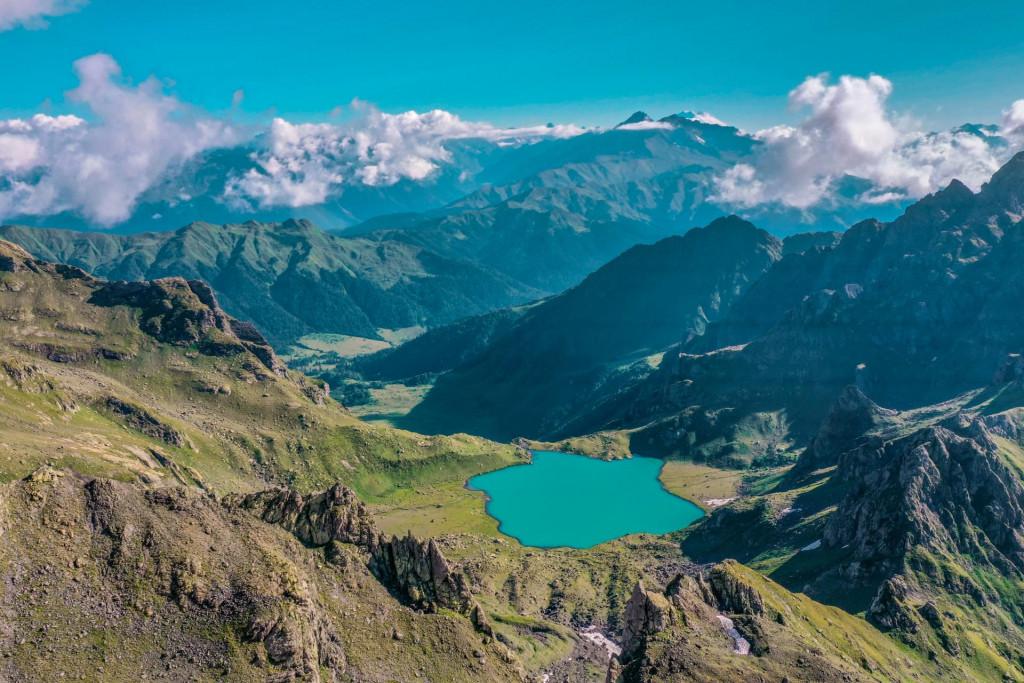
The route to Big and Small Okrostskali lake is one of the least known and at the same time the most impressive route in Georgia. The magnificent panoramic views and amazing lakes overlap the efforts made to see the lakes. Big Okrostskali lake has the colour of the turquoise and makes you feel that you are at the seashore, while small Okrostkali has a darker colour.
To reach the lakes you need to get to village Lukhi in the Khaishi commune, where any type of vehicle can get. The hiking trail starts 25 km from the village of Lukhi. The 25 km section from village Lukhi to the beginning of the trail can be covered by off-road vehicle or 20 km by a truck which can be rented (with driver) in the village.
The first part of the trail goes along the abandoned vehicle road heading to Abkhazia and descends into the forest after the exit from the main road. Soon after the road descends into the gorge the route comes to the „Into The Wild” point and switches from the road to the path. After that, the path goes through the forest for around 1.5 km and you will have to overcome dirty sections. Next section of the trail before the river crossing (around 1.5 km) is the field with high vegetation. It is difficult to find the trail and navigate through the field. In the field, you can see the old cottage which is connected to the horror stories from the war of Abkhazia according to stories locals recall.
After the field, you will have to cross the river Ormeleti then it ascends small uphill to the forest. The height of the grass decreases. The trail goes through small yet very beautiful forest where you can see the texts cutouts on the trees.
From the forest, the trail gets to the huge valley which is surrounded by the rocks and make a wonderful panoramic view. You can see the river Okrotskali flowing down on 400 meters high slope and creating a cascade of waterfalls. Obviously, the lake Okrotskali is the source of the river.
After the field, the most difficult part of the trail starts, which is the last ascend to the lake. There is no path, the incline is high, the surface is covered with grass and partially with stone. It goes on the left side (right bank of the river Okrotskali) of the cascade of the waterfalls. You should gain 400 meters in elevation, which requires a lot of effort.
The route from Big Okrotskali to Small Okrotskali Lake is very dangerous. You have to cross a narrow ridge, a very steep slope and climb a rock whose terrain varies from year to year. You have to ascend 550 meters in the vertical and overcome pass Ergzashira and the second pass as 2900 MSL which is on the line of the occupied territory. Here is the administrative border between Svaneti and Abkhazia. You can enjoy a beautiful panoramic view of Abkhazeti and In good weather, you can even see the sea.
The hiking trail is of medium difficulty, however as we mentioned the last section of the trail is quite difficult, the last ascent is quite steep, which requires a lot of effort to overcome, however the beauty at the end of the ascent makes us forget everything.
Offers nearby
42.960059
, 42.195953
Duration:
3 days
Total distance: 20 km
Difficulty: Hard
Our guides are ready to help you on this trip
+58
Book a tour online!
Buy our tours online and explore incredible Georgia!
See all
Map

Where to stay In Svaneti

Bude - Cottage in Svaneti
Cottage

Eco huts in Mestia
Cottage

Hut of Love
Cottage

Ushba Cottages
Cottage
1 Reviews

Please login to ask a question
Ask a Questionგამარჯობა, თვის ბოლოს ვაპირებთ ლაშქრობას ოქროსწტყლის ტბებზე იქნებ საკონტაქტო მითხრათ ვინმემ ურალი რომ დავიქირაოთ
599 65 68 37
გამარჯობა,
ორ კვირაში ვგეგმავ ოქროწყლების ტბებზე ლაშქრობას. მაინტერესებს რა მდგომარეობაა ბილიკზე. რას ფიქრობთ რამდენად მეწყერსაშიში ლოკაციაა, არსებობს თუ არა მსგავსი ტიპის საბრთხე.
ასევე როგორი სასიარულოა ლუხიდან ქოხამდე ფეხით, რამდენად რეკომენდირებული და დაფარვადია ერთ დღეში ქოხამდე და ფეხით წასვლის შემთხვევაშ არის თუ არა გზად დასაბანაკებლად რაიმე ადგილები. ასევე წყლის პრობლემა არ უნდა იყოს წესით.
ურალის დაქირავებას და ამ მონაკვეთის ურალით გავლასაც განვიხილავ და თუ მოგეპოვებათ საკომუნიკაციო ნომერი რომ გავიგო რა ჯდება დაქირავება და შევუთანხმდე, ან თვითონ ლუხში რომ ჩავიდე რამდენად შესაძლებელია რომ ადგილზევე ვიპოვნო ვინც აგვიყვანს. ურალის დაქირავებას ლუხში შევძლებ თუ ხაიშში? ადგილზე ძებნას უკეთესი იქნებოდა წინასწარ დავკავშირებოდი.
მადლობა წინასწარ 🥰
გამარჯობა,
მაღალი კლიენსის მქონდე ორხიდიანი ჯიპით სამანქანო გზას სრულად გავივლით? არის ისეთი რთული მონაკვეთები რომლის გავლა მარტო სატყეო ტრანსპორტით არი სესაძლებელი?
ასევე, ასაწევი სიმაღლიდან გამომდინარე წესით 2 დღეში მოსწრებადი უნდა იყოს ეს მარშუტი? თბილისიდან ტრანსპორტირების დროს თუ არ ჩავთვლით
უშუალოდ ლაშქრობას 2 დღე ეყოფა (თბილისიდან მგზავრობის გარეშე). 2 დღეში მოივლი დიდ ოქროწყალს, თუმცა პატარა ოქროწყალის მოსწრება ძალიან გაგიჭირდება. პატარადან დიდამდე გადასვლაზე მინიმუმ 2 საათი წაგივა და სახიფათო მონაკვეთი აქვს. კლდეზე გიწევს აფოფხება (წელს როგორ დაგხდება ვერ გაიგებ). მაღალი კლირენსით გამიჭირდება გითხრა. მე land Cruiser 78-ით სადამდეც შეიძლება მანქანა მივიდეს მივედი. იმის იქით გზა არ შედის. დაწერე მანქანის მარკა და მოდელი და შევეცდები გირჩიო შეხვალ თუ არა ბოლომდე.
სალამი მეგობარო , Honda CRV თუ შეძლებს ასვლას , ისე რომ მანქანა არ გავწიროთ
Hi! What do you think, is it possible to pass the 25 km section from village Lukhi to the beginning of the trail by Toyota Sequoia 4x4 SUV car? Are there difficult sections that can only be traversed by trucks?
გამარჯობა,
რაიმე რჩევას ხომ არ მომცემდით ამ მარშრუტზე. წყლის საკითხიც მაინტერესებს. მადლობა წინასწარ.
სალამი, ამ მარშრუტზე წასვლას გირჩევთ იმ შემთხვევაში თუ ხართ გამოცდილი მოლაშქრე. უნდა გაითვალისწინოთ რომ რაღაც გარკვეული მანძილი დიდ ბალახებში გიწევთ სიარული, და შესაბამისად აუცილებელია კომფორტულად გეცვათ. მზისგან დამცავი კრემი წაიღეთ. მარშრუტზე წყალი გხვდებათ სამანქანე გზაზეც, ასევე გზად მდინარეების გადაკვეთა გიწევთ და მათი წყალიც ვარგისია დასალევად. უშუალოდ ტბაშიც ჩაედინება მცირე ნაკადული და მისი დალევაც შეგიძლიათ.
gamarjobat
mainteresebs saidan xdeba gasvla
მოგესალმებით, ლაშქრობას იწყებთ სოფელი ლუხიდან.