
Juta- The Colorful Lakes Of Abudelauri- About Roshka

About Juta- The Colorful Lakes Of Abudelauri- About Roshka
Best time to visit:
Summer, September
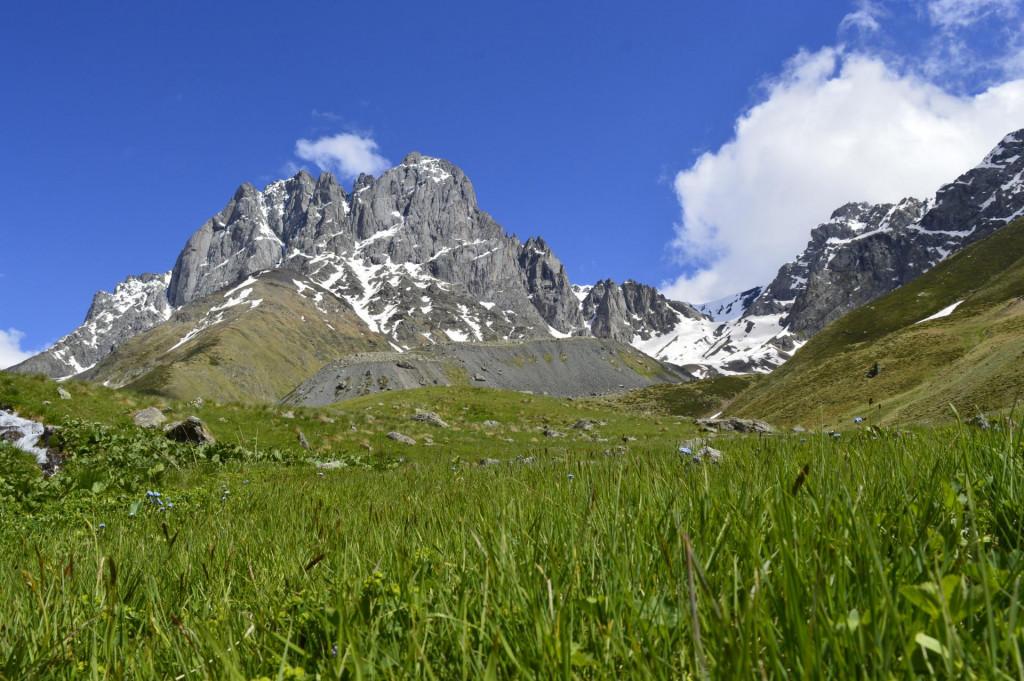
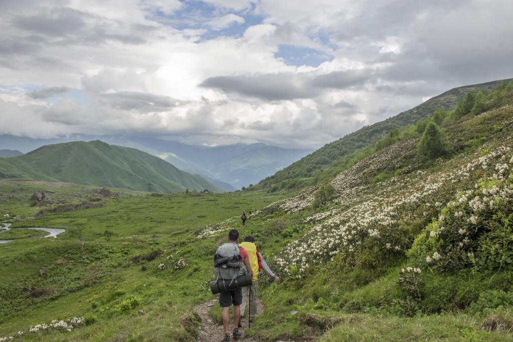
Summer is the best season for traveling in the Georgian mountains. The landscape, heated by the sun and snow melting, gives you an opportunity to climb 4000 meters height without any special equipment. To do so, you only need a tent and waterproof shoes. In the region of Mtsheta-Mtianeti, there is one of the most beautiful and popular crossings from Khevi to Khevsureti, which is the hiking track of Juta-Abudelauri lakes. The route starts in Juta- at one of the highly populated spots (2200 meters above sea level) and ends in Roshka.
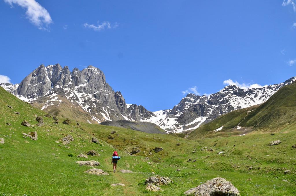
It is possible, but not easy, to arrive in Juta by hitchhiking, because for the past 12 km, from Sno to Juta, the natives practically do not walk. There, you can only meet taxi drivers and tour guides. Thus, if you are unwilling to wait on the road for a long time or walk 12 km by foot, it is better to rent a taxi in Stepantsminda. At the beginning of the track, you will meet “Zeta Camping” and “Fifth Season”, which offer the campsite, comfortable rooms, restaurants with national dishes, horses, and plenty of other amusements for the guests. On weekend, due to its beautiful nature and various pleasant services, lots of people arrive here for recreation, to spend time agreeably, and to enjoy the delightful views. After “Zeta Camping” the trail leads to the left side of the river Chaukhi Massif. After 4 kilometers, the trail turns left, here you will find a campsite. This place is the mountaineers’ camp. It is a bad idea to camp there if you only have two days for the trip. However, if there is no time limit, you can camp there and enjoy the magnificent sceneries of Chaukhi Massif. If you carry on the path, after 3 km, 3000 meters above sea level, you will meet at the next campsite. If you reach this place exhausted or by the evening, it is preferable to spend the night there, because you will not meet such a proper site for camping and the route from there until the lakes are quite hard.
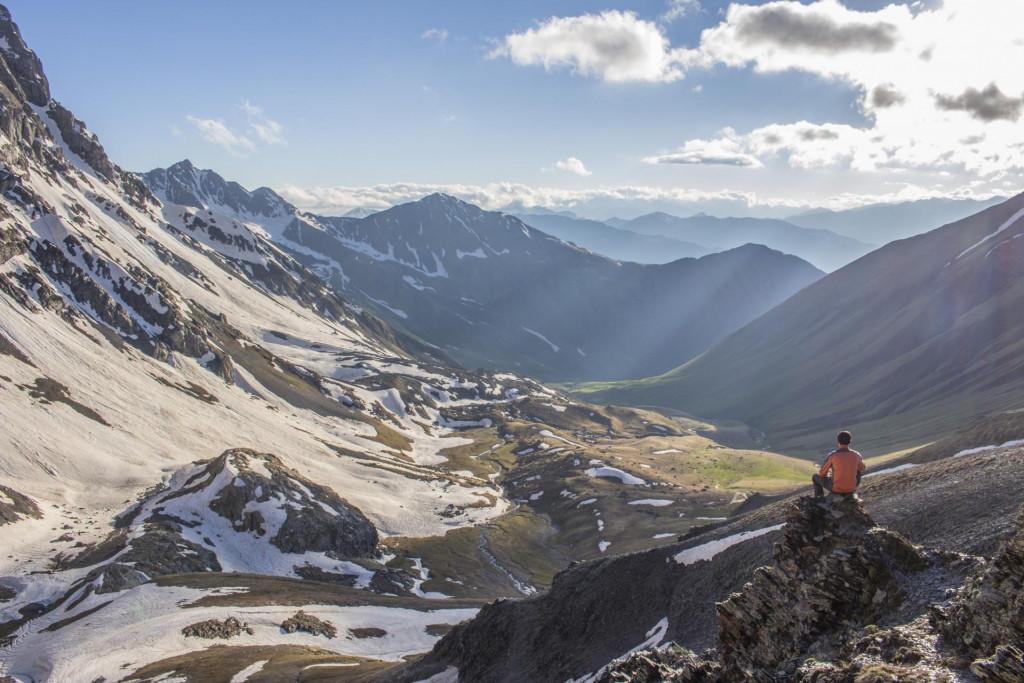
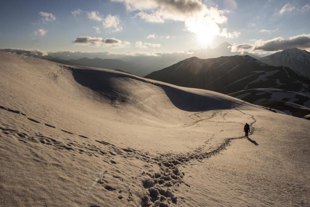
On the next day, you continue the route to Chaukhi pass. It takes two hours to climb the pass. It would be best, if you climbed there in cloudless and fogless weather, in order to enjoy the magnificent sceneries. In front of you, the wonderful valley of Khevsureti will spread out and besides, you will see the glacier “Queen of Georgia” and the summit „Shino“. After walking the pass, there are two options: descending a steep path, on the right, straight to lake, or using the easier, less bent path, which goes along the mountain range towards Blue Lake. Blue Lake is the perfect campsite because there is drinking water from rivers, which flows down Green Lake. Green Lake is very close to Blue Lake, thus you can visit it at any time. White lake is 1 km away from these two lakes and it takes approximately one hour to get there. The road is rocky, full of big, shapeless rocks which makes walking harder.
7 kilometers away from Abudelauri Lakes, is located the village of Roshka. It takes 2 hours to get there. You can try to return home by hitching or continue the route to Zhinvali-Shatili road, which is located 5 km away from Roshka, there is a higher chance to depart by hitchhiking from there.
USEFUL ADVICE
The preferable season to pass the route is from June to October. If walking in the snow causes discomfort for you, it would be better to go there in August. The path is quite good, because lots of people walk there every day. For this route, the recommended equipment are: Waterproof hiking boots, hiking sticks, hiking gas cylinder for boiling water, as there is no wood 2000 meters above sea level. You will also need warm clothes and the raincoat, because the weather in mountains is unpredictable. There is no mobile connection in Juta, so it is better to save the maps in the mobile cache if you are using mobile app for navigation. Also, it is best to have a mobile power bank charger for your cell phones. The big stock of water is not necessary, because, on this route, there are plenty of rivers that can be used for drinking, unless there are horses and cows around. It is recommended to buy the food in Stepantsminda or Tbilisi, because prices are high in the mountains and there is not a wide range of choices.
See the detailed route on the map. If you need additional information or just want to share your experience, please leave a comment.
Transportation:
.
Offers nearby


42.579803
, 44.745542
Duration:
2 days
Total distance: 22 km
Difficulty: Easy
Our guides are ready to help you on this trip

+58
Book a tour online!
Buy our tours online and explore incredible Georgia!
See all
Map

Tours In Mtskheta - Mtianeti
2 Reviews

This route is great for beginners, because it's super beutiful and not so hard.
If you are a beginner and want to enjoy stunning views of Khevaureti region, pak your backpack and get there. You will get tired but this experience will remain in your mind forever.

ამ მარშრუტის გავლა უმჯობესია ივნისი ივლისის თვეში, როცა თოვლი ახალ დანადნობია, ჭაუხები კი ჯერ კიდევ თოვლით არის შემოსილი, თქვენს წინ იშლება უმშვენიერესი ხედი და ეს ხედი არეკლილი სხვადასხვა ფერის, ზომისა თუ ფორმის ტბებში , რომელიც საუცხოო სანახავია.
Please login to ask a question
Ask a Questionგამარჯობა, როშკის გადასახვევამდე რითი შეიძლება მივიდე? რამე საშუალება თუა ტრანსპორტის (მარშუტკის, ცოტა ბიუჯეტურის) მაქამდე რო მიმიყვანოს და მერე ფეხით განვაგრძო? თუ მხოლოდ თიანეთის მარშუტკას თუ გავყვები და მერე გადასახვევზე ფეხით უნდა გავაგრძელო ან აუტოსტოპით ვინმე თუ გამიყოლებს ეგ ვცადო? შუა კვირაში რო წავიდე მოძრაობა მაინც არის რო რამე? მადლობა
ტრეკი გადმოვწერე და არ იხსნება მობილურში. გუგლ მაპის გარდა რამე სხვა აპი უნდა?
გამარჯობა. Google Map-ში არ გაიხსნება ტრეკი. გჭირდებათ სხვა აპლიკაცია. მაგალითად: GPX viewer, Osmand, Gaia, Fatmap... მსგავს აპლიკაციებში შეძლებთ ტრეკის გახსნას. 💜
გამარჯობა, ჯუთადან თეთრ ტბამდე რამდენი კილომეტრია ? ლურჯი და მწვანე ვნახე ხევსურეთის მხრიდან, თეთრი დამრჩა სანახავი და მინდა ჯუთადან მისვლა, დაახლოებით რა დროს მოვანდომებ? დიდი მადლობა წინასწარ
გამარჯობა, საშუალოდ მოსიარულე მოლაშქრე ერთ დღეს ანდომებს უღელტეხილის გადავლას ჯუთიდან თეთრ ტბამდე (7-8 საათი). თეთრ ტბაზე უკეთესი სანახაობა უღელტეხილიდან ხედებია. თეთრი ტბიდან უჯობესია როშკის მხრიდან დაბრუნბდე შინ.
დიდი მადლობა ^^
ჯუთამდე პატარა მანქანით თუ არის შესაძლებელი მისვლა? (ივლის-აგვისტოს თვეში)
მოკლე ბაზის მქონე სედანს თუ გაიმეტებთ კარგ ამინდში ახვალთ. პირადად მე არ წავიდოდი სედანით.
მადლობა დიდი!
გამარჯობა,
მაინტერესებს რამდენად შესაძლებელია იგივე მარშუტის როშკას მხრიდან გავლა ჯუთასკენ?
ასევე, ტბებთან თუა საკარვე ადგილები ან თუარა ერთ დღეში თუმოესწრება უღელტეხილზე გადასვლა?
მადლობა წინასწარ.
კი შესაძლებელია, თუმცა როშკას მხრიდან გადასვლა უფრო რთულია, რადგან ტბებიდან უღელტეხილზე ადის ძალიან რთული ბილიკი რადგან დიდი სიმაღლის აწევა გიწევთ სწრაფად. ჯუთადან უფრო მარტივია რადგან ნელ-ნელა ადიხარ უღელტეხილზე.
საბანაკეს რაც შეეხება ლურჯ ტბასთანაც შეიძლება დაბანაკება და უღელტეხილს რომ გადაივლით იქაც. თუ ტბებზე დაღლილები ახვალთ სჯობს ლურჯ ტბასთან დაბანაკდეთ და მეორე დღეს ძალიან ადრე დაიწყოთ რომ 5-6 საათში მაინც გადაიაროთ უღელტეხილი და საღამოს ჯუთაში იყოთ.
თუ ადრე მიხვალთ ტბებთან გადაიარეთ ბარემ უღელტეხილი და ცოტას რომ დაეშვებით იქვე დაბანაკდით სადმე.
მთლიანი მარშრუტის ერთ დღეში მოსწრება თითქმის შეუძლებელია ჩვეულებრივი მოკვდავისთვის.
მადლობა ძალიან დიდი
მოგესალმებით,
მაინტერესებს, ფეხით სნოს გადასახვევიდან რამდენი დრო დამჭირდება ჯუთაში ასასვლელად და საბანაკე ადგილებში ცეცხლის დანთება თუ შეიძლება და ადგილზე შეშა თუ იშოვება?
მოგესალმებით კობა, სნოს გადასახვევიდან ჯუთამდე 15 კმ-ია გასავლელი. ფეხით დაახლოებით 4-5 საათი დაგჭირდებათ. საბანაკე ადგილები ამ მარშრუტზე არის ალპურ ზონაში სადაც შეშას ვერ იშოვით. უმჯობესია თან იქონიოთ სალაშქრო გაზქურა.
გამარჯობა, მაინტერესებს რამდენად რეალურია დამწყები მოლაშქრეებისთვის ერთ დღეს ჭიუხვებში დაბანაკება და მეორე დღეს უღელტეხილზე ასვლა და ისევ უკან ჩამოსვლა? შესაძლებელია თუ არა რომ კარგ ამინდში უღელტეხილამდე გზა აგებნეს?
მადლობა წინასწარ :)
დიახ, შესაძლებელია. რუკაზე ნაჩვენებია ორი საბანაკე ადგილი ჯუთას მხარეს, შეგიძლიათ დაბანაკდეთ ამ ორიდან ერთ-ერთ ადგილას. რაც შეეხება გზის არევას, მთაში გზა შეიძლება პროფესიონალსაც აერიოს GPS მოწყობილობის გარეშე. გირჩევთ დააყენოთ რომელიმე აპლიკაცია და ჩაწეროთ ამავე მარშრუტზე მოცემული GPX ტრეკი (იხილეთ რუკის ტაბი).
ჩვენივე საიტზე შეგიძლიათ ნახოთ სტატია GPS აპლიკაციებზე და მათი გამოყენების შესახებ.
მაინტერესებს მანქანით რო წავიდე სანამდე მივალ მანქანით //
ეს მარშრუტი არ არის წრიული, შესაბამისად რეკომენდებული არ არის მანქანით მისვლა. თუმცა თუ მაინც გადაწყვეტთ, რომ მანქანით მიხვიდეთ და შემდეგ ისევ უკან, მანქანასთან დაბრუნდეთ მაშინ ჯუთას მხრიდან ჯუთამდე შეიძლება 4X4 მანქანით მისვლა.
ხოლო თუ მეორე მხრიდან, როშკაში გსურთ მანქანით მისვლა, აქაც მიდის 4X4 მანქანა. მას შემდეგ რაც არხოტის გზა გაიყვანეს უკვე შესაძლებელია მანქანით გასცდეთ როშკას და დამატებით 2-3 კილომეტრით მიუახლოვდეთ აბუდელაურის ტბებს.
ჯუთადან დილით რომ დავიწყოთ , აბუდელაურის ტბებს ვნახავთ და უკან, ჯუთაში დაბრუნებას მოვასწრებთ?
ეგ თითქმის შეუძლებელია საშუალო დონის მოლაშქრეებისთვის. შეგიძლიათ ახვიდეთ უღელტეხილზე და იქედან გადახედოთ ტბებს, შემდეგ კი უკან დაბრუნდეთ.
მაგრამ თუ უღელტეხილიდან ტბებზე დაეშვებით უკან დაბრუნებას ვეღარ მოასწრებთ.