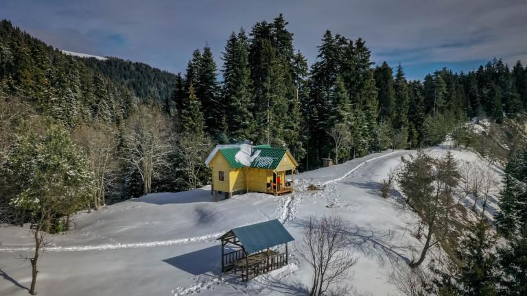
Lomismta Tourist Shelter
Tourist Shelter


The trail links Nikoloz Romanov and St. Andrew routes and two overnights in Amarati and Lomismta shelters are needed. During the trail, you will come across following attractions: Lomismta, Lomismta St, Giorgi church, scenic viewpoint with Caucasus scenery, Shepherd’s cabins, panoramic views of Lesser Caucasus.
Rout starts from the Borjomi-Kharagauli National Park entrance and goes along the road. The trail crosses the river with the footbridge. After the footbridge, you will find the information board. From the information, board trail continues to the left and goes uphill with the serpentine. you are ascending all day long, however, there are relatively horizontal sections which giveს you the possibility to rest. Trail is well marked and visible year round. First day distance is 13 km. At the end of the day when the trail gets back to the vehicle road, you turn left and the road takes you to the shelter.

This day is longer and more difficult. On the trail, you will see shepherd’s summer farms, where they are keeping cattle during summer. The path ascends Lomistma, goes along the ridge, connect to mountain Megruki by the gorge and descends to Amarati tourist shelter.

Last day of the trail is relatively easy. The trail descends all day long and gets to Atskuri ranger station.
.
Our guides are ready to help you on this trip

Buy our tours online and explore incredible Georgia!

Help other travelers use your experience.
Review this destination, share your thoughts, impressions, pros and cons.
Let's make traveling easier than ever.


Please login to ask a question
Ask a QuestionHello,
Can you tell me if horseback riding is possible? indicated in the parameters
Hello, about horseriding in Borjomi-Kharagauli national park, you must contact the park administration. +995 591 88 74 44
Is it possible to hike this trail in mid-April?
Hello, it depends on the snow level. For detailed information you can connect Borjomi-Kharagauli National Park administration via number: +995 591 88 74 44
Thank you for Your answer. I tried to write them through chatbox but have not get any answers so far. Is calling more certain thing to get contact? :)
Hi There, your GPS-Track of sheperds trail has a "non-official" part. From 41.82359°N, 43.13649°E where it leaves the blue blazes until the sheperds hut on 41.84575°N, 43.14219°E where it gets to yellow blazes, there is no path at all, hundreds of fallen trees, dense vegetation and a overgrown creek. Perhaps you should add a warning at least. Official path follows the red blazes from Amarati shelter and continues with yellow blazes north of it. Thank you! :)
Hi Christian, Thank you for reporting the problem. We've not hiked on this track for a long time and there might be some issues. We will take a closer look and fix the problem. Thank you again and have a great time in Georgia
Hi, I have hiked the trail from the Lomismta shelter to the Amarati Shelter and can agree on the statement from Christian. The GPX track is at this part incorrect and not hikable.
The traveller should follow at a shepherds hut the marked yellow trail to the right and hike to the ridge, then follow the red marks to the left and pass mount Megrukhi and Mount Amarati and proceed to the shelter. The way is longer than the GPX track, but with no major technical problems.
The GPX track, as described by other hikers, is at this location unpassable. There are lots of fallen trees, often there is no path, and the ascent is extremely steep.
Please add a warning that the GPX track should not be followed at that spot. Thanks for your support.
Dear Benjamin, Thank you for bringing this up to us. We updated the GPX file and it would be great if you could help on checking whether we got it right?
Thank you in advance