The administrative center of Tetritskaro is one of the most beautiful places where you can easily plan a day trip. Impressive natural monuments, such as the Samshvildi Canyon , the Birtvisi Cliffs, and the distinctive feature of this region - the Birtvisi Fortress, make Tetritskaro an interesting travel destination. Mountains, gorges, open spaces, menhirs, fortresses, settlements, tombs, temples, and ancient streets lined with ditches are a list of things you will definitely enjoy when you come to Tetritskaro. In addition to the above-mentioned places, there are many interesting monuments from different periods here. Cyclopean structures, defensive fortifications, and churches-monasteries tell interesting stories about Georgia. If you want to relax while spending your time spectacularly, then head to Manglisi. The town of Manglisi is located in the Tetritskaro municipality and its surrounding area is rich in ancient archaeological sites.
We present to you the 10 best places in Tetritskaro Municipality that you must see:
Birtvisi Castle has been considered an impregnable fortress since ancient times. Birtvisi Castle is located in the Tetritskaro municipality, in the Algeti Gorge, in the Kvemo Kartli region. It was a very strong and strategic fortress and played a major role in the history of Georgia. The fortress and the magnificent views of the Birtvisi Canyon make a great impression on the visitor and are a very popular place for hiking enthusiasts.
The fortress consists of several parts and includes both military and residential and agricultural buildings. The fortification function of Birtvisi Fortress is inscribed in the natural rock massif. Steps and a water supply system are carved into the rock. Below the fortress there are springs in the cistern, and above there are reservoirs where rainwater was collected through grooves on the walls. Near the Birtvisi spring there is a tower, which is the lower boundary of the fortress defense complex, from which a historical path leading to the fortress rises between the rocks. The tower is 2 stories high. On the road to the Birtvisi Mother Fortress there is the main gate, which has the function of a gorge lock.
The second gate is located on the territory of the Mother Fortress, it closes the canyon leading to the lower terrace of the Mother Fortress. In the vicinity of the Mother Fortress, on the highest rock, there is a cylindrical watchtower - "Sheupovari", the walls of which are equipped with guns. This tower must have been built in a later period, although much earlier layers are found in these areas.
The date of construction of Birtvisi Fortress is unknown. It is first mentioned in historical sources in the 11th century, although, according to researchers, it must have been built much earlier. It did not lose its significance as a fortress until the end of the 18th century and was considered impregnable, having been taken only a few times, as a result of great efforts. It is distinguished by
The Samshvilde Canyon natural monument is a combination of the deep canyon-like Khrami Gorge and the Chivchavi Canyon carved out of lava rocks. In addition to its beautiful views, Samshvilde is also known for its historical and cultural significance. The entire history of Georgia, from the megalithic past to the late Middle Ages, is concentrated here.
The closest large settlement to the natural monument is the city of Tetritskaro. Tetritskaro is 58 km away from Tbilisi; duration - 1 hour;
The village of Manglisi is one of the best places to relax in a resort near Tbilisi. The village is located in the Tetritskaro municipality, on the southern slope of the Trialeti Range, on the left bank of the Algeti River.
Manglisi and its surrounding area are rich in ancient archaeological sites. The Bronze Age burial mounds discovered on the Bedeni Plateau are noteworthy. In ancient times, there was a significant settlement on the site of Manglisi. In later times, the road passing through here contributed to the advancement of Manglisi, which connected Shida Kartli with Sakhmet Georgia, Armenia, and Byzantium. Historical sources testify that Manglisi was one of the oldest centers of the spread of Christianity in Georgia. The first church was built here in the 4th century.
Algeti National Park — a national park in eastern Georgia. Located in the historical Kvemo Kartli region, in the Tetritskaro municipality. It is located in the Algeti River gorge and covers the southern slopes of the eastern part of the Trialeti Range. It is located at an altitude of 1100-1950 m above sea level, the highest point is Kldekari (2000 m). It is distinguished by its landscape and biological diversity.
There are currently five eco-tourist routes on the territory of Algeti National Park. Horseback riding and hiking. Only one of them is marked - "Royal Ridge". - A 16 km circular route. The route goes from the town of Manglisi in the direction of the picnic area, through Martalkhevi to the village of Didi Namtvriani and returns to Manglisi along the Royal Ridge. From the viewpoints on the trail, the valley of Algeti National Park and mountain ranges covered with mixed forest are spectacularly visible.
Along with enjoying the views of the Algeti River Gorge and mountains, you will visit the natural monuments of Dashbashi, the aforementioned Birtvisi and Samshvildi canyons, and the Kldekari fortress.
Partskhisi Castle – a fortress in Tetritskaro Municipality, Kvemo Kartli region. It is located on a high hill on the left side of the Algeti River.
There is no record of the construction of Partskhisi. Although it is mentioned in the chronicles only from the reign of Bagrat IV (1027-1072), it must have been built much earlier.
For the castle's owners, it seems, its inaccessibility was not the determining factor, but the strategically chosen location was the main one. The castle was located on one of the main roads of Kvemo Kartli. From here, such famous castles as Birtvisi, Orbeti, and the Kojori area to the southeast were clearly visible.
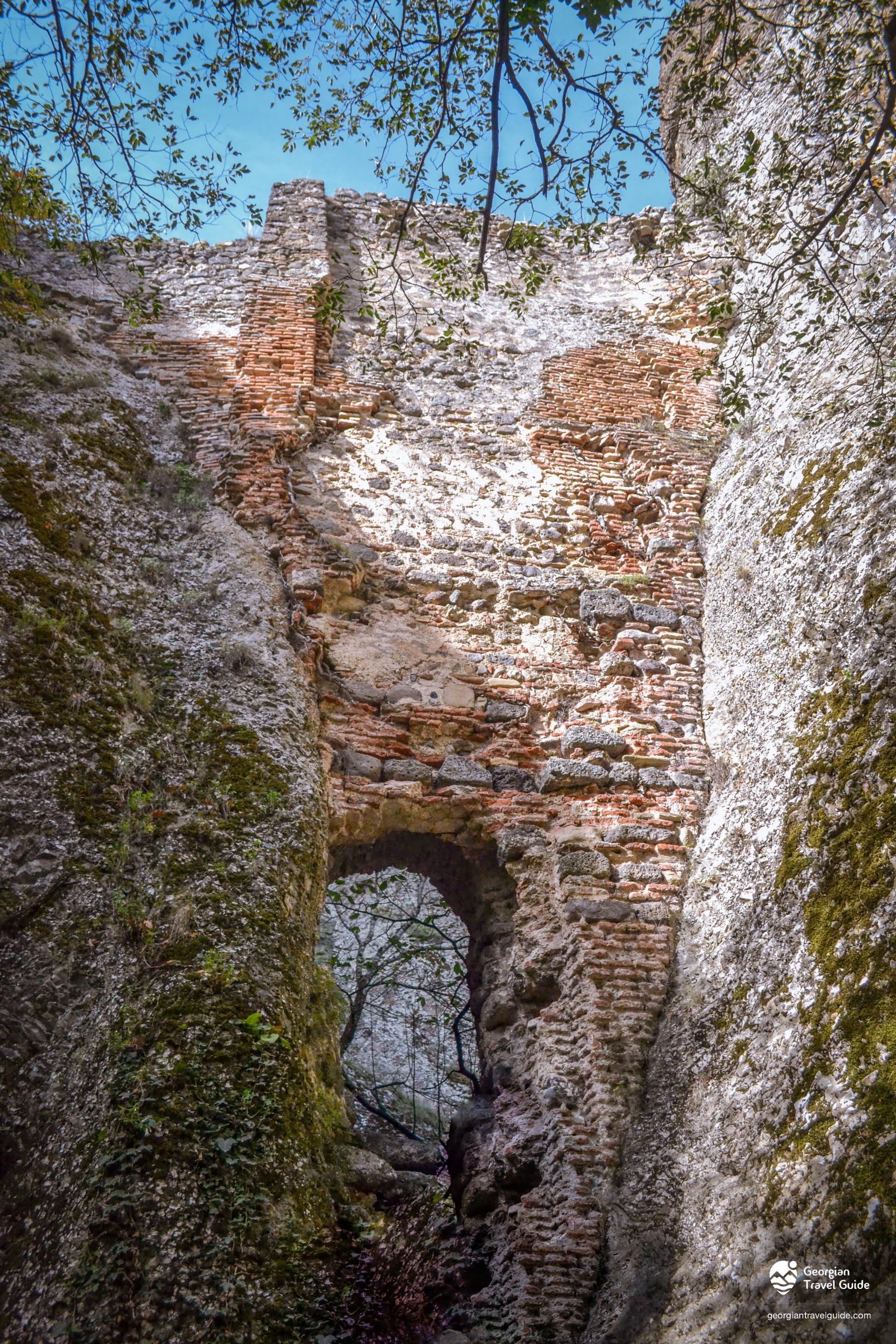
The fortress is in ruins, and only here and there the walls remain. Before the excavations, the plan was not completely readable. The fortress had a long plan, with rounded ends. Apparently, the fortress consisted of two parts. The central part was occupied by the citadel along its entire length, and a rampart ran around it, almost concentrically, traces of which are now visible only to the west and north. There is no entrance to the outer walls of the fortress, while the upper one is to the north. The gate is wide and was covered with an arch. Unlike other sections, brick was used here and bears clear traces of restoration. The old walls of the fortress are made of cobblestone and rubble stone. In some places, hewn stone is also used in the upper layers. The western section of the citadel was separated. This section is enclosed by double walls. According to the chroniclers, there must have been a large tower with three or four towers. To the east of the gate is a small storage room, from which the tunnel begins.
Samshvildi Complex is one of the oldest historical fortress-cities in Georgia, preserved in ruins. It is located near the present-day village of Samshvildi, in the Tetritskaro municipality, Kvemo Kartli.
A naturally fortified cape at the confluence of the Chivchavisada and Khrami rivers was selected for the city, with rocky, jagged cliffs on two sides and a wall surrounding it on the third side.
In the city of Samshvilde there are ruins of many fortifications, cult and other buildings, the most important of which is the monument of Georgian architecture of the 8th century, the central-domed great episcopal cathedral of Samshvilde Sioni. According to Leonti Mroveli, Samshvilde is connected with Kartlos, archaeological excavations confirm that life in Samshvilde was still in the 4th-3rd centuries BC. It was from this period that Samshvilde was an important city throughout history.
The Khrami River (also known as the Ktsia) is a river in eastern Georgia, flowing through the municipalities of Tetritskaro and Kvemo Kartli. In its upper reaches, it is called the Ktsia. The Khrami originates on the slopes of the Trialeti Range and flows into a deep valley. It is fed mainly by snow, does not freeze, and is used for irrigation in its lower reaches. The Tsalka Reservoir and 3 hydroelectric power stations are built on the Khrami. The Khrami tributaries are: Debeda, Mashavera (right), and the Tsalka Reservoir is built on it.
From the 1920s of the 19th century, Tsarist Russia began to resettle German colonists in Georgia. A large part of the German Swabians who settled in the vicinity of Tbilisi, and in 1819, a German settlement was established in the Tetritskaro municipality - the village of "Elizabettal" (present-day Assureti).
By the end of the 19th century, Elisabethtal was a well-developed and economically exemplary village. The agricultural sectors were particularly developed: viticulture, grain growing and potato growing, and the products were sold in Tbilisi. German colonists created important social and cultural institutions in Assureti, which played a major role in the socio-economic and cultural life of the population. Unique material monuments of their existence have survived to this day: residential and farm buildings, a unique wine cellar, a Lutheran church built in the Gothic style and residential houses built in the Old German architectural style.
The village was called Elizabeth until the 10s of the 20th century, then it returned to its original name - Assureti. The village is characterized by German architecture. An old German church built in 1871 has survived. A German settlement existed here until 1941, when they were deported from Georgia by order of Stalin. There is also a German cemetery here. In 1941, part of the population of Ambrolauri and Oni districts was resettled in Assureti.
Khuluti Fortress is an immovable cultural monument of national significance. Khuluti Fortress is located in the Tetritskaro municipality, in the narrow gorge of the deep gorge of the Khrami River, in the vicinity of the Pitareti Monastery. It consists of 2 parts; each has one tower, and the ramparts have 5 towers. Each of them is primarily for residential purposes, and then for military purposes. The northwestern tower is a tower-like palace in function, divided in the middle along its entire height by a wall with steps. One side is 6-storey, the other - 7-storey. The last floors are intended for military purposes, the rest - for residential purposes. The entire fortress is built of local rock stone.
The tower overlooks the river from a fairly high cliff. It can be reached by a tunnel leading uphill. The complex one-story residential building in the tunnel itself seems to have played the role of a distributor, since from here it was possible to get to two other towers, a tunnel leading down to the river, a toilet and other places. Between this building and the tower is a large reservoir. Above them there was a bathhouse, and guns are lined up in the walls.
Alexander Orbeliani provides information about the construction of the Khulut fortress. One of the Korchibash of Shah Abbas, who was called Vakhtang before the conversion to Islam, asked Kaplan Orbeliani to raise his son in Iran. Kaplani sent his youngest son Orbeli. After some time, Orbeli returned to Georgia and brought with him a letter and money sent by Korchibash. In the letter, Korchibash wrote to Kaplani that he was secretly a Christian and requested the money sent to decorate the small temple in Fitareti. Given the difficult situation, Kaplani built the Khulut fortress with that money. Korchibash also sent money that was used for the church. Thus, the Khulut fortress was built by Kaplani Orbeliani in the first half of the 17th century.
Khuluti Castle was not only a castle but also a fortress. The castle can be entered through several doors. The main gate is located on the south side. It is also possible to enter the castle through a tunnel that goes down into the river valley. The exit of the tunnel was guarded by a special tower.
The castle is built mainly of local, quarried stone.
Khulut Fortress was mentioned as a reliable and strong fortress even in the 18th century.
The village of Gudarekhi is located in the Kvemo Kartli region, in the Tetritskaro municipality, on the eastern slope of the Bedeni ridge, at an altitude of 1,100 meters above sea level. The village has been inhabited since ancient times, and a Bronze Age settlement has been discovered here. Gudarekhi is mentioned in the following written sources: Vakhushti Bagrationi's "Description of the Kingdom of Georgia", historical documents of the 16th-18th centuries, Ioane Bagrationi's "Description of Kartli-Kakheti". In the 16th century, it was the ancestral village of the Baratashvilis. The road from Samshvildi to Manglisi passed here.
The village is located in a beautiful place, with magnificent views of the Algeti Reservoir and the vast expanses of Kvemo Kartli. In addition to its natural beauty, Gudarekhi is also distinguished from a cultural point of view, as it is home to a very important cultural monument - the Gudarekhi Monastery Complex. You can also visit the Gudarekhi Tower and the residence of Kakutsa Cholokashvili in the village.
A monument was discovered in the vicinity of Gudarekhi - a settlement, which consists of 2 parts: a monastic complex surrounded by a high wall with towers built of cut stone, and a settlement located to the north and northwest of the wall.
Gudarekhi was previously called Gvoristavi and was renamed to its current name on April 19, 1947.

 GEO
GEO  ENG
ENG  RUS
RUS 










 LOGIN WITH GOOGLE
Please login to add a comment
Write a comment